+1 805 664 0090

Request DemoFree Trial

Wetland Delineation: USACE Pioneer

Anita Henry 0 Comments

Wetland delineation, together with the regulation and monitoring of species and habitat within these areas, is under the jurisdiction of the US Army Corps of Engineers (USACE). Their role is to ensure environmental compliance to protect the waters of the U.S. and to help bring threatened and endangered species back from the brink of extinction.

The methodology of USACE oversight, however, is thanks to a key group of environmental biologists. Environmental pioneers who painstakingly laid the groundwork for current ecological practices.

Founding USACE Wetland Ecologist

Charlie Newling was among those first tasked with figuring out how to protect precious wetlands from encroaching development. Specifically, figuring out the role that wetlands play, and how they should be identified.

environmental compliance, USACE regions, wetland delineation form, wetland calculations, USACE

“I used to pray to be able see a nesting pair [of Peregrine Falcons] in the wild before they went extinct,” Charlie says. “Now, in Wisconsin, their numbers are almost back to where they were before they were listed.” Eagles and Sandhill Cranes have also rebounded. “I can see Eagles in my backyard! You couldn’t do that back in the seventies.”

cols-image

Swamp School class engaged in field training

The Swamp School

Based in Angier, North Carolina, the Swamp School offers post-secondary/college classes and webinars in wetland assessment, delineation and design, and other topics relating to the management of wetlands. The classes are designed to help environmental professionals enhance their skills and expand their business. Wildnote will be included in all of the Swamp School’s wetland delineation courses, whether offered in the classroom, online or on-demand sessions.

Automated Forms with Professional Wetland Training

The Swamp School has the ability to provide the wetland and IT technical support that students need to successfully use technology to collect data and report on wetland delineations. Marc pointed out that many of the issues with the wetland delineation data collection software products arise not from an inability to use the software but from a fundamental misunderstanding of what data needs to be collected, how, and why. By combining the wetland training with the software training, students will seamlessly integrate digital technology into their delineation projects. The newly-formed partnership was immediately put to use.

testimonial-img

Senior PWS and Swamp School Founder, Marc Seelinger, is excited about the changes ahead.

“The Swamp School is committed to providing a cutting-edge education for modern wetland scientists, who expect technology solutions to better their work. Wildnote elevates our curriculum, making the Swamp School the only wetland training program in the U.S. to offer a mobile technology component. We look forward to working with Wildnote to help our students perform more accurate and reliable delineations and to advance the state of the art in wetland evaluation technology.”

- Marc Seelinger

Charlie Newling didn’t set out to be a pioneering wetlands ecologist. He just wanted to be able to keep fishing and eating duck dinners. As development encroached on more wild places, Newling, like others, saw we could not continue taking without giving back. This enlightenment ignited a massive environmental movement, a wave that met the relentless mid-century push toward suburban sprawl head-on. Environmental consciousness migrated from the hearts of the people to the law of the land. People, plants, and animals would have to share. Great, but how? Nobody really knew.


Bird with a hooked beak, dark gray head ad white underbelly flecked with gray looks directly into a camera close up. It's mouth is slightly open.
Temporarily eradicated from the eastern United States, a Peregrine Falcon poses for a nest camera in Wisconsin.


Preserving US Wetland Regions

Charlie’s backyard eagles are just a few miles down the road from “The Shack,” a place made famous in Aldo Leopold’s seminal book, “Sand County Almanac.” Sometimes called the father of modern wildlife ecology, Leopold also wrote one of the first books on game management. This is the land that Charlie loves, land he learned how to nurture so that it may in turn nurture others.

Charlie graduated college as a Biologist and Wildlife Ecologist in the 1970’s. People were tired of acid rain and combustible rivers, so they did something. The National Environmental Protection Act (NEPA) had just been enacted, and the Clean Water Act (CWA) soon followed. That act tasked the newly minted Environmental Protection Agency (EPA) with cleaning up the nation’s waters.

Subsequent lobbying and legal wrangling eventually put the US Army Corps of Engineers (USACE) in charge of permitting activities in and around all yet-to-be-defined wetlands. According to Charlie, when the USACE was ordered to expand its navigable waterways jurisdiction to include wetlands, it responded by asking, “What’s a wetland?” Charlie was there to help figure that out.


12 people are standing in from of a small, old, wooden structure with a peaked roof on one side. Large trees surround the structure.
Charlie Newling (center, in orange vest) and students from the Wetland Training Institute at Aldo Leopold's famous "Shack."


Wetland Delineation: USACE Initial Region Mapping

Fate delivered him to the Corps via telegram (yes, a telegram). He listened as the operator seemed to read him a job offer from the New England division of the USACE. The words had to push through a slight fog. The night before he attended a going-away celebration for two lucky friends who had gotten jobs with Fish & Wildlife in Alaska. “Surely, they meant to offer an interview, not a job,” he thought hazily. The operator assured him the telegram said “job.” It was much later that Charlie discovered how they came to offer him a job at the USACE without so much as an interview.

Like many others, Newling applied for civil service positions by signing up on the Federal Register.

“A friend told me to sign up in as many categories as I could to qualify for more positions. He said it’s hard to get in, but once you’re there, it’s easy to transfer. Well, I didn’t know any better, so when I saw ‘general biologist’ I thought, well, anybody who’s a biologist would qualify for that, and I almost didn’t sign up on that register, but I ended up checking the box.”

That box, and some well-received library research he did for the USACE as a grad student, changed the course of his life, and ours.

cols-image

Swamp School class engaged in field training

The Swamp School

Based in Angier, North Carolina, the Swamp School offers post-secondary/college classes and webinars in wetland assessment, delineation and design, and other topics relating to the management of wetlands. The classes are designed to help environmental professionals enhance their skills and expand their business. Wildnote will be included in all of the Swamp School’s wetland delineation courses, whether offered in the classroom, online or on-demand sessions.

Automated Forms with Professional Wetland Training

The Swamp School has the ability to provide the wetland and IT technical support that students need to successfully use technology to collect data and report on wetland delineations. Marc pointed out that many of the issues with the wetland delineation data collection software products arise not from an inability to use the software but from a fundamental misunderstanding of what data needs to be collected, how, and why. By combining the wetland training with the software training, students will seamlessly integrate digital technology into their delineation projects. The newly-formed partnership was immediately put to use.

“When I was hired, the head of the USACE permits department didn’t exactly know what he needed. He just knew he needed a biologist who could do a lot of stuff to help him figure out if there were really wetlands out there to be regulated. He also needed someone he could work with. At that time, his experiences with biologists had all been negative and adversarial. He listed the position as a general biologist, which lots of applicants qualified for. But then he added that he wanted someone who ‘showed positive, past experience with the Corps of Engineers.’ That eliminated everyone but me.”

Wetlands Inventory Mapper, Science and Compliance Take Hold

And so began the first regulatory attempts to define and map wetlands. The first order of business? To create the standards, practices and forms that biologists would need to do their work. Distilling dynamic complex systems into concrete legal definitions is a slippery, arduous task. Without digital technology, GIS, or the internet, that initial creation of documents was laborious, and painstakingly slow.

In fact, it took nearly a decade to finalize the first version of what is now called the National Wetland Plant List (NWPL). Innovation was necessary to develop a methodology for identifying a wetland—a methodology that didn’t require someone to be a master plant expert at a time when few existed. Regions were defined, first by geo-political lines, then, later, by ecological characteristics.

Newling and his colleagues helped invent what is now the National Wetlands Classification Standard and put some of the first pins in the National Wetland Inventory map. Today, the Department of Fish & Wildlife’s Wetlands Mapper tool can do in minutes what took a small group of pioneers years to accomplish.


Four mature men dressed in jeans and T-shirts stand side by side in a large meadow with forest trees in the background.
Pictured in 2001, these wetland all-stars helped write the 1987 Corps of Engineers Wetland Delineation Manual. L to R - Dr. Tom Straw (Hydrogeologist), Dr. Bob Pierce (Wetland Ecologist), W. Blake Parker (Soil Scientist), Dr. Charles Newling (Wetland Scientist).


The ‘How-to Manual’: Identifying and Delineating Wetlands

In addition to serving on the committees that meticulously assembled the U.S. Fish and Wildlife Service’s “National List of Plants that Occur in Wetlands,” Charlie Newling literally helped write ‘The Book’ on how to identify and delineate wetland communities for regulatory purposes – the “1987 Corps of Engineers Wetland Delineation Manual.” With research that started about 1980 and culminated in 1987, Charlie considers his work on that manual, and the training he’s conducted that followed, to be his biggest contributions. “It’s the grandaddy document that underpins all the rest,” he says. He also advised the Corps of Engineers’ team working on the “1989 Federal Interagency Manual on the Identification and Delineation of Jurisdictional Wetlands,” and was on the peer review team for one of the first “Regional Supplements to the 1987 Corps of Engineers Wetland Delineation Manual” (the Arid West).

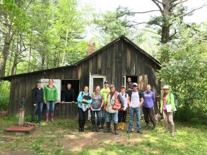
Nearly 30 years later, as a co-founder and instructor at The Wetlands Institutehe has helped train generations of wetland scientists. Thanks in part to him, what once was rare is now common. He gathered his skill set under the guidance of exceptional professors and holds deep gratitude for their influence. “I thank the Lord every year that goes by, and I think of these guys and thank them for what they gave me.” That must go both ways, because on May 31, 2018, Dr. Charles Newling received the 'R. Harold Jones Lifetime Achievement Award' from the Society of Wetland Scientists, for his contributions to the discipline.

Wildnote's Wetland Delineation Forms Receive Expert Guidance

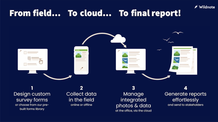
Thanks to Charlie Newling and his mentorship, protection of our wetland ecology has grown from an idea to an industry. He has helped it develop from books and paper forms to mobile phones and tablets. He helped guide Wildnote’s development of digital wetland delineation forms. These electronic forms let Wildnote users efficiently collect, manage, and submit the exact field data required for wetland reporting in the exact format the USACE requires. Taxonomy lists, auto-calculations, photo management and a host of other tools enhance data collection speed, consistency, and accuracy.

Wildnote first released wetland delineation forms for the Arid West and the Western Mountains, Valley, and Coast USACE Regions. These forms received such an enthusiastic reception from biologists at the NMEBC Conference, that Wildnote followed by rolling out the wetland delineation forms for all 10 USACE regions. As of this update, more than 2,000 wetland determinations and 1000 wetland monitoring reports have been submitted using Wildnote, and version 4.0 is on deck for release soon. “Thanks Charlie!”


A closeup of a smiling man with gray hair, glasses, brown shirt and a white jacket.
Charles J. Newling, Wetland Superstar!
testimonial-img

Senior PWS and Swamp School Founder, Marc Seelinger, is excited about the changes ahead.

“The Swamp School is committed to providing a cutting-edge education for modern wetland scientists, who expect technology solutions to better their work. Wildnote elevates our curriculum, making the Swamp School the only wetland training program in the U.S. to offer a mobile technology component. We look forward to working with Wildnote to help our students perform more accurate and reliable delineations and to advance the state of the art in wetland evaluation technology.”

- Marc Seelinger

image1

The Wildnote process integrates and streamlines data from the field to final report

Choosing Wildnote for a Wetland Technology Partner

Seelinger spent years looking for the right technology to integrate into the curriculum. He said he chose Wildnote because it is a complete platform that supports the entire process of wetland data collection, management, and reporting.